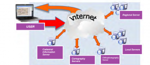
We can define an SDI (Spatial Data Infraestructure) as a computer network system composed by a group of resources (catalogues, servers, programs, data, applications, WebPages, and so on) that manage the Geographic Information such as maps, orthophotography, satellite images, toponims, etc. They are available to download online. This information supplies interoperability conditions (rules, specifications, protocols, interfaces, etc.) that allow the user to download and use them, with only a web browser.

An IDE (Integrated development environment) allows to:
- Search for the Geographic Information available for a geographic area, including the format, the form to access to it, and the metadata.
- Visualise and overlapping , maps, orthophotographies, DTM, any type of geographic data from different organizations, with different reference system defined, in different formats and heterogeneous properties.
- Search for a concrete geographic feature, by its name and where it is located within the cartography.
- Access the geographic features in a standard format, as well as its attributes coordinates, topology and geometry.
- Carry out basic analysis, such as routing, profile calculations an surface analysis.
- Carry out transformations from one data model to another one, if both data are described in an normalised form.
- Download the data needed to carry out a powerful analysis in a GIS desktop software.
We can say that SDIs were born in 1994, from the Executive Order 12906, of United States. From then, all the English-speaking countries followed this process of developing and displaying Geographic Information on Internet. Canada, Australia and New Zealand developed new SDIs.
From the INSPIRE Directive, all Europe has to have national SDIs. And then, countries from South America started to develop their own SDIs.
In a supranational sphere, several SDIs have been developed, such as: Permanent Committee for the Asian and Pacific SDI, the Permanent Committee for American SDI (PC-IDEA) and more SDIs for Africa. Lastly, the Global Spatial Data Infrastructure (GSDI) in an organization that keeps resources and activities (Website, forum and annual congress) for mantaining SDIs projects around the world.
Click on each one to access the SDIs:
What attributes does the Geographic Information have?
- Position: location of a concrete geographic feature in which a coordinate system is defined, as well as the cartographic projection (absolute position) and / or the reference points known regarding to the relative position. This Position answers to WHERE?
- Thematic variables or attributes: provide the characteristics of a geographic feature. These variables answer to WHAT? HOW?
- Time: this sets the chronologic scale for a geographic event. It answers to WHEN?
- Spatial Relationships: these are referred to the types of connections among geographic features.
- Dimensions: allow the user to refer to the variety of geographic objects according to the considered dimensions, distinguishing among point objects (no dimensioned), lineal objects (one dimension), polygon objects (three dimensions) known as flat surface objects, and volume objects (three dimensions) (Santos, 2002).

From this, we can say that if you want to search for a concrete data, you should go first to your local government Webpage, and access to its SDI. If your data is not in that SDI, you should look at the SDI of the country, and if it still is not in that one, continue to a more global SDI. Nevertheless, don’t forget that there are another data resources that you can process in your computer, using a powerful GIS software, in order to obtain the results you want.

You can manage it by taking any of our courses, because we are professionals training professionals.
Our courses in LIDAR analysis will be able soon.
But first, we recomend you to take a look at our courses in ArcGIS, learning the basics and of course, being able to carry out vector analysis and, depending on which course you are studying, managing Raster data model.
- To get these steps, you can start from manipulating the data and understanding the vector data model in our ARCGIS BEGINNER COURSE
- If you want to extend your knowledge for Raster data (all types of data which are considered as raster data, such as DTMs) you can study ARCGIS ADVANCED COURSE
- Otherwise, both studie are possible in our ARCGIS SPECIALIST COURSE , as well as an specific one in
Which are you interested in?
Finally, if you are using the ArcGIS software , or desire to get the knowledge for it, take a look at out course catalog here.


Leave A Comment